Overview
This 3-day course covers the fundamental principles of spatial sensing technology, such as scene representation, scanning and mapping, and spatial reasoning from sensor data, as well as practical workshop sessions that allow participants to simulate and implement hands-on spatial sensing and reasoning techniques.
Course Description & Learning Outcomes
This course is part of the Artificial Intelligence and Graduate Certificate in Intelligent Sensing Systems Series offered by NUS-ISS. At the end of the course, participants will be able to: - Acquire the fundamentals of spatial sensing and spatial reasoning technology, including scene representation, scanning and mapping, spatial reasoning using feature-based approaches and the state-of-the-art machine learning based approaches. - Apply critical analysis, evaluation and synthesis to a wide range of spatial sensing and spatial reasoning problems. - Build spatial sensing and spatial reasoning systems in diverse areas such as robotics and augmented reality.
Recommended Prerequisites
- No prior experience with spatial sensing reasoning is assumed, although previous knowledge of 3D vision and robotics will be helpful. - Participants should have intermediate skills in Python programming (e.g. Numpy, Pandas). - Participants are required to have an intermediate knowledge of computer vision at the level of Vision Systems e.g., image processing, feature extraction and representation. - Participants should be familiar with Tensorflow/Keras to build deep convolutional neural network model (e.g., VGG) to perform image classification and Python-based OpenCV programming to extract LBP/HOG features from the image. - Intermediate mathematics and statistics knowledge, e.g. calculating matrix multiplication, probability.
Pre-course instructions
- No printed copies of course materials are issued. - Participants must bring their internet-enabled computing device (laptops, tablet etc) with power charger to access and download course materials. Registration close date: 04/01/2024
Schedule
Date: 25 Jan 2024, Thursday
Time: 12:00 AM - 12:00 AM (GMT +8:00) Kuala Lumpur, Singapore
Location: NUS-ISS, 25 Heng Mui Keng Terrace, 119615
Agenda
| Day/Time | Agenda Activity/Description |
|---|---|
| Day 1 | - Introduction to spatial sensing and reasoning from sensor data - Spatial sensing: 3D sensor data representation and modelling - Workshop on 3D sensor data representation and modelling, such as constructing 3D scene map based on image/video captured by the camera |
| Day 2 | - Spatial reasoning: Scanning, mapping, localization - Workshop on scene mapping and localization from sensor data, such as building a camera-based localization system for place recognition |
| Day 3 | Spatial reasoning: Object and scene recognition - Case studies and workshop on design and build a spatial reasoning system, such as building a vision-based inspection system for building defect inspection and inventory checking in warehouse - Final written assessment test |
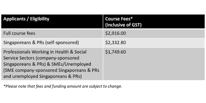
Pricing

Partners


